Chania | Greece | Venetian Harbour | Week 29

Chania [greek: Χανιά; turkish: Hanya], was already inhabited by the Minoans and the Greek called it Kydonia, it lies about 100 km west of the capital of Crete Heraklion and about 300 km south of Athens across the Aegean sea. It is the 9th largest city in Greece and the 2nd largest on Crete.

Population: 108.000 [2011] | 54.000 [1991] | 26.000 [1928] | 20.000 [1900]

Chania is the major city in western Crete, including a large ferry port and an international airport. The Kydonians were mentioned twice in Homer’s Odyssey. During its history the city belonged to the (often together with all of Crete) Minoans, Ancient Greek, Byzantines, Saracens, Venetians, Genoese, Osmans and modern Greek. It was mainly the Venetians and later the Osmans that developed the city, created its harbour and made it an important centre for commerce and administration. For more than 300 years (1651-1971) the city became the capital of Crete.

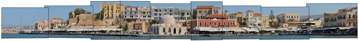
Our panorama depicts the eastern side of Chania’s old venetian harbour, which was created in the 13th century. In the background we can still see the old byzantine walls that surrounded ancient Kydonia and which is now the city quarter Kasteli. The main feature here is the former Küçük Hasan Pasha Mosque, built by the Osmans after conquering the city in 1645. Its minaret was torn down in 1920 and today it houses a public gallery. The old town of Chania is still defined by its old venetian and osman architecture and the centre of the city is a protected historical monument – the reason for it being the most popular cretan harbour with tourists.

Click for larger view:

Venetian Harbour Port in Chania, Crete

For classic view and more infos about the place:

Kydonia Harbour Venetian

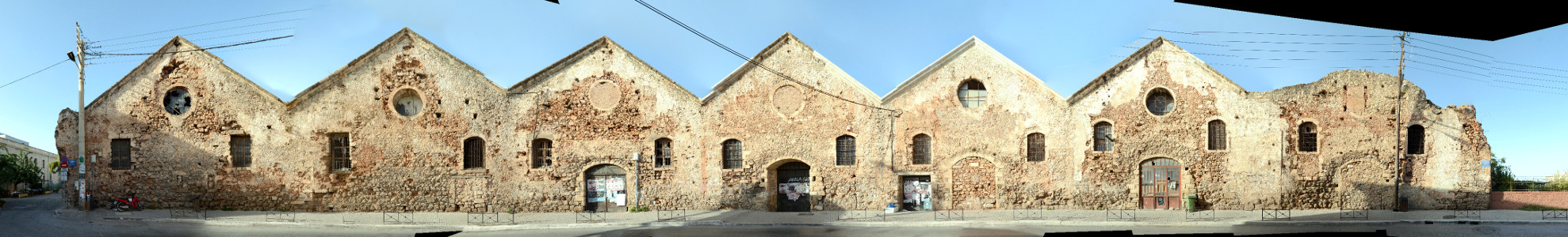
We documented more streets and places in Chania. Below you can see a preview of a backside view of the old venetian shipyards (Megalo Arsenali) from Kallergon street.

Megalo Arsenali Chania

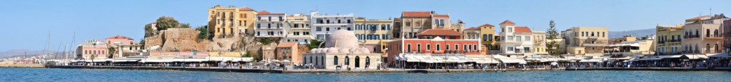
And here is also a preview of the south and west front of the venetian harbour of Chania.

Hafen Chania Westseite Panorama Foto

For more streetlines of Greece visit our archive.

Edinburgh | United Kingdom | Victoria Street | Week 20

Edinburgh [scottish gaelic: Dùn Èideann; french: Édimbourg], the hill forth Din Eidyn by the Gododdin tribe was built sometime before 600 AD and the city was founded as a royal burgh in the early 12th century. Situated about 70 km east of Glasgow and ca. 550 km north of London on the southern shore of the Firth of Forth. 2nd largest city in Scotland, 8th largest city in the United Kingdom and 61st largest city in the european union.

Population: 493.000 [2014] | 419.000 [1991] | 439.000 [1991] | 395.000 [1901]

Edinburgh, lying east of Glasgow in the scottish central belt, has been the capital of Scotland since the mid 15th century, hence it is the seat of the Scottish Parliament and of the monarchy in Scotland. The city is a UNESCO world heritage site since 1995, notably for its Old Town with Edinburgh Castle, the Holyrood Palace and the Royal Mile connecting the two, as well as the planned 18th century Georgian New Town. The city is also home to the National Museum and the National Library of Scotland as well as the Scottish National Gallery. Today the city is known for its strong economic, especially in the financial sector and the tourism industry, as well as its cultural festivals, especially the Edinburgh International Festival and the Fringe Festival.

Victoria Street is the historical, being called West Bow then, entrance to the Castle Hill from western direction. It was transformed to its current shape in the early 19th century and renamed Victoria Street when Queen Victoria was crowned. Most buildings were errected in the mid 19th century, though some older buildings remained at the foot of the street. Here we see the grand India Buildings from 1864 on the left and the former St. John’s Church from 1838 in the middle.

For more Edinburgh street views visit our Edinburgh Architecture blog post.

Click for larger view:

Edinburgh Panorama street view photography

For classic view and more infos about the street:

Edinburgh Streetview Photography Scotland

We documented several more streetline views in the Old Town and New Town of Edinburgh (see Edinburgh blog post) including the complete Royal Mile. This section of the Royal Mile (Lawnmarket) has been published before:

Scotland Royal Mile Photography

And a preview of the Royal Mile along the High Street:

Edinburgh Royal Mile Panorama

Another unfinnished preview of the Jenners department store in the New Town:

Edinburgh Jenners Preview