Schneeberg | Germany | Fürstenplatz | Week 35

Schneeberg, founded in 1471 when silver was found below the mountain. It lies 200 km south of Berlin, 300 km east of Frankfurt and 150 km northwest of Prague. It is the 51st largest city in the state of Saxony, Germany.

Population: 13.900 [2019] | 22.300 [1984] | 13.600 [1946] | 6.900 [1834]

Schneeberg is a so called Bergstadt (mountain city). The city name can be translated to ‚Snow Mountain‘. When large silver deposits were found around the Schneeberg mountain in the late 15th century this prompted a mining boom (Berggeschrey) and a settlement quickly emerged. It took the new city only 10 years to gain the status of a free mountain city and in 1483 the Saxon Elector founded the Schneeberger Münze (mint facility). A legend tells the story of the Saxon Elector Albrecht dining on a table made entirely of silver in a local mine. The city quickly became rich and one of the largest late gothic churches was built in the 16th century – the St Wolfgang Church. Later the mining shifted towards other deposits like cobalt, wismuth and uranium until it was finally abandoned in 1957. In 2019 the Ore Mountains (Erzgebirge) became a UNESCO world heritage site, which inlcudes several places belonging to the city of Schneeberg.

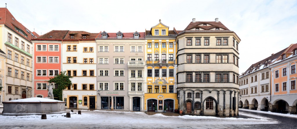
In 1719 a city fire destroyed Schneeberg, but the wealthy city was quickly rebuilt – in baroque style which gives it some distinction in the Erzgebirge area. The panorama above presents a street front which exemplifies why Schneeberg is now called the Barockstadt im Erzgebirge (Baroque City of the ore mountains). The panorama depicts a side of the Fürstenplatz square which includes the Schmeil-Haus (left), the Fürstenhaus (Sparkasse) and the cultural centre „Goldne Sonne“ (right).

Schneeberg is celebrating its 550 years jubilee in 2021.

Click for larger view:

Schneeberg Barockgebäude Fürstenplatz

For classic view (german link):

PanoramaStreetline Schneeberg 101 cityscapes

Seminarstrasse Preview:

Seminarstrasse Schneeberg Sachsen

Find more Streetlines from the Erzgebirge (Ore Mountains) Area in our Archive.

Münster | Germany | Prinzipalmarkt | Week 34

Münster, founded in 793 when the missionary Liudger founded a monastery here, lies 200 km east of Amsterdam and 400 km west of Berlin. It is the 10th largest city in the state of Northrhine-Westfalia, but also the 20th largest city of Germany.

Population: 313.000 [2017] | 259.000 [1990] | 120.000 [1930] | 64.000 [1900]


Click for larger view:

Münster Leinwand Prinzipalmarkt Rathaus

For classic view:

Prinzipalmarkt Münster Architektur

Also in our archive, the opposite side of Prinzipalmarkt (german link):

Prinzipalmarkt Münster Giebelhäuser

Görlitz | Germany | Augustastrasse | Week 30

Görlitz [polish: Zgorzelec], first mention as Goreliz in 1071. It is the easternmost city in germany, lying about 80 km east of Dresden, 120 km west of Wroclaw (Breslau) and 120 km north of Prague. Görlitz is the 6th largest city in the german state Saxony and the largest within the region Upper Lusatia (Oberlausitz).

Population: 55.000 [2015] | 72.000 [1990] | 94.000 (1930) | 81.000 [1900]

Görlitz is especially known for its well preserved old town, it is member of the working group historic cities in germany. From its early times the city belonged to the bohemian kingdom, later it became part of Saxony, then Silesia (in Prussia) and finally Germany (incl. GDR). It was a strong trade city in late medieval times, esp. due to its monopoly for woad trade in Bohemia. Görlitz was a member of the Lusatian League and as such held rights similar to free imperial cities for some time. In 1945 the new border between Germany and Poland cut through the city along the Neisse river. It’s eastern part is now an independent city – Zgorcelec in Poland. Economically the city has a long history in the production of trams and trains. Nowadays the city is also a favourite spot for big movie productions, earning it its nickname Görliwood.

The street front above is a section of Augustastrasse, a street full of examples of historicism style, which is common in the areas around the old town centre. Görlitz is also known as a so called Pensionopolis, an attractive city with relatively low rents that attracts the elder and retired people. While the city experienced an economic decline since 1990 it still managed to restore the majority of its historic buildings – in large parts thanks to the anonymous Altstadtmillion (old town million). Between 1995 and 2016 each year the city received an anonymous amount of one million Deutsche Mark (later that amount in Euro) to be spent for reconstructing the old town. The results can be seen all over Görlitz.

Click for larger view:

Architektur Görlitz Sachsen Lausitz Schlesien

For classic view and more infos about the place (german here):

Görlitz Architecture Panorama

We documented more streets and places in Görlitz. Find some previews below. For more views from saxon cities follow the link to our Saxony archive.

A panorama of the central block on the lower market square (Untermarkt).

Untermarkt Görlitz Panorama Foto

The Brüderstrasse between Obermarkt and Untermarkt with the Silesian Museum (left).

streetview Görlitz Brüderstrasse old town streetline

A section of the Obermarkt (Upper Market) from 2011.

Oberlausitz Görlitz Architektur Fassaden

The main station.

Görlitz Bahnhof train station

Frankfurt | Germany | Mainufer | Week 28

Frankfurt am Main [italian: Francoforte sul Meno], first mention as Franconofurd in 794, but probably inhabited since the Romans. Frankfurt is situated ca. in the middle of the line Brussels – Prague and about 400 km south of Hamburg. It is the largest city (but not the capital) of the german state Hesse, the 5th largest in Germany and the 48th largest in Europe.

Population: 733.000 [2015] | 645.000 [1990] | 541.000 [1930] | 289.000 [1900]

Frankfurt had been one of the most important cities in the Holy Roman Empire ever since the division of Charlemagne’s Frankish Empire in 843. From 1147 to 1792 most german kings and emperors were crowned in Frankfurt. The city became a free imperial city in 1220 and kept this status till Napoleon. After a brief period of dependance it was a free city again until it was annexed by Prussia in 1866. Frankfurt gained a status as an important trade fair city as early as the 13th century and it established an early currency exchange system in the late 16th century. Today it is the leading financial centre of continental europe, a leading trade fair city and a significant cultural and commercial centre, including central europe’s busiest airport.

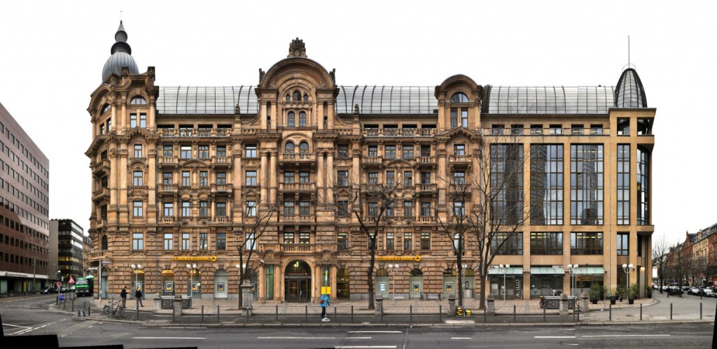
This linear panorama view depicts the northern shore of the river Main from the Bankenviertel (banking district) on the left along the central old town of Frankfurt up to the Alte Brücke (old bridge) on the right. Prominent features are the banks skyscrapers on the left, which form the basis for all classic skyline images of Frankfurt, in the centre of the panorama we see the towers around the central square Römerberg and further to the right we see the large Frankfurt Cathedral (german: Kaiserdom St. Bartholomäus). One main feature is missing from this view however, in the middle the river is crossed by the Eiserne Steg bridge, a pedestrian connection to the south bank. See our archive version for more infos, backgrounds and an explanation of the bridge’s dissapearing.

Click for larger view:

Frankfurt Mainkai mit Bankenviertel und Skyline im Panorama

For classic view and more infos about the place (german link):

Frankfurt Mainkai Panorama

We documented more streets and places, which can be seen in our Frankfurt overview.

Some of these examples:

Kaiserstrasse

Kaiserstrasse streetview Frankfurt panorama image foto

Römerberg | City Hall | Nikolaikirche (unfinnished)

Römer Frankfurt Markt Römerberg

Gallusanlage (unfinnished)

Gallusanlage Frankfurt Main Commerzbank

Greiz | Germany | Train Station | Week 21

Greiz, first mentioned as Grewcs in 1209, lies 80 km south of Leipzig, 120 km west of Dresden and ca. 250 km east of Frankfurt on the river Weisse Elster. 18th largest city of the german state Thuringia (german: Thüringen).

Population: 21.000 [2014] | 36.000 [1984] | 39.000 [1931] | 23.000 [1905]

Greiz, also nicknamed the „Pearl of the Vogtland“ is situated in the thuringian Vogtland, named after the Vögte (advocats) of Weida, Gera, Plauen and Greiz. First a residence in the mid 13th century it has been home to the „House of Reuss“, a ruling german dynasty, from the 14th century to 1918. They have built the two castles in the city, the Oberes Schloss (Upper Castle) and Unteres Schloss (Lower Castle). As a former residence city Greiz is known for its representative buildings, some of them in Art Nouveau style, and the english style Greizer Park with its Sommerpalais (summer palace).

Here we see the main train station building of Greiz with its annexe buildings. The station building was errected in the 1870s when the connection to Plauen was established. At the time of this photograph in 2014 it was uninhabited and as a sign on its door declares „for sale“ – though trains are still stopping at the station. However we chose this street view as an example of train stations in linear panorama views. The historic station buildings all over europe often occupied a complete street front hard to be photographed in its entirety. You can find more examples in our train station archive.

Click for larger view:

Bahnhof Greiz Thueringen Panorama

For classic view and more infos about the streetview (german link):

train station germany greiz

Previously published streetlines from Thuringia and Greiz

Yet unpublished here is a linear view of the central ensemble with the Lower Castle, the Gymnasium and the Upper Castle in the back:

Greiz Panorama Unteres Oberes Schloss

We documented a number of train station buildings across europe (inlcuding Istanbul, Prague, Paris, Milan, Glasgow…) which are yet unedited, here are some unfinnished examples:

Görlitz Bahnhof train station

Quedlinburg train station germany

Bahnhof Rheinland Pfalz Worms

Öuxor train station test photography

Prague train station

top to bottom: Görlitz, Quedlinburg, Worms, Luxor, Prague


Munich | Germany | Residenz München | Week 17

Munich [german: München], first mentioned 1158, lies 350 km west of Vienna, 300 km north of Venice and 500 km south of Berlin on the shores of the Isar river. It is the 3rd lagest city in Germany and 19th largest city in Europe.

Population: 1.439.000 [2014] | 1.229.000 [1990] | 729.000 [1930] | 500.000 [1900]

Munich has become the seat of a bavarian duke in 1255 and in 1506 it became capital of all of Bavaria. Munich hosted the 1972 Olympic Games and is home to the Oktoberfest, the world’s largest Volksfest. The city is a financial and cultural centre of Germany and home to Bayern München, one of the most prominent football clubs of europe.

Here we see the complete west side of the Munich Residenz, which had been the Residence of the Bavarian Rulers from 1508 to 1918. The Residenz is the largest city palace of germany. The main facade here was built as the Maximillianische Residenz in the early 17th century and is dominated by two portals flanked by lions and a statue of the mother of god as Patrona Bavariae. On the right end we see the side facade of the Königsbau next to the Max-Joseph-Square.

We have captured a number of Streetlines in the bavarian capital, find a summary of the material we worked on in our Munich overview.

Click for larger view:

Munich Residenz Residence

For classic view and more infos about the square (german link):

Muenchen Residenz

Zwickau | Germany | Hauptmarkt | Week 15

Zwickau, founded in the 12th century, lies 60 km south of Leipzig and about 150 km northwest of Prague at the foot of the ore mountains [german: Erzgebirge], 4th largest city in the german state Saxony and 88th largest city in Germany (2014).

Population: 91.000 (2014) | 122.000 (1988) | 85.000 (1930) | 56.000 (1900)

Zwickau quickly gained importance after its foundation and was a free imperial city in the early 14th century. Besides Wittenberg it was an early centre of the Lutheran Reformation. From the 15th to the 20th century Zwickau was a centre of the mining industry in Germany, especially for hard-coal from Zwickau and silver from the ore mountains. Hence the city played an important role in german industrialisation and was for centuries one of the main economic and cultural centres of Saxony. It is also a cradle of the german automobile industry with Audi and Horch being founded in the city, while during the GDR times it was the city of the Trabant, the most well known car of the eastern bloc.

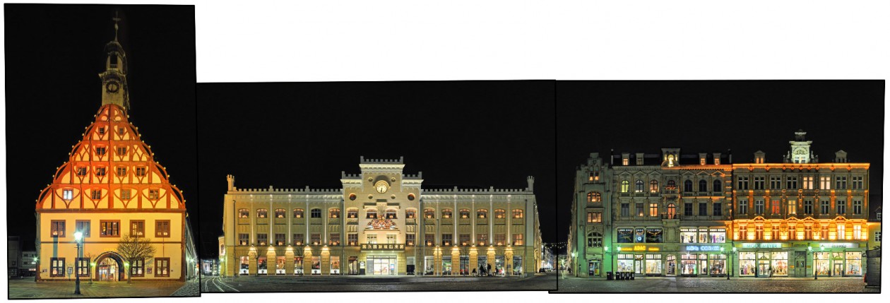
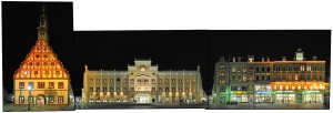
Here we see a night view in christmas lighting of the southern side of the main market square (Hauptmarkt), which includes two of the cities main buildings, the Gewandhaus on the left and the town hall in the centre. The Gewandhaus (cloth merchants‘ hall) was built in the 16th century and today serves as the main theatre of the city. The town hall was built in 1404 and features the elaborate city emblem above its portal. The last building on this side of the square on the far right, which was unfortunately hidden by christmas stalls for this photography, is the birthplace (and museum) for the famous composer Robert Schuhmann.

Visit our archive for other streetline panoramas from Saxony.

Click for larger view:

Zwickau Gewandhaus Rathaus Hauptmarkt

For classic view (english link):

Zwickau Gewandhaus

Düsseldorf | Germany | Königsallee | Week 12

Düsseldorf [Dutch: Dusseldorp], founded in 12th century, got city rights in 1288, lies on the shores of the Rhine, 30 km north of Cologne and 170 km east of Brussels, 2nd largest city in the Bundesland Nordrhein Westphalen (Northrhine-Westphalia), 7th largest in Germany and 66th largest in europe.

Population: 605.000 (2014) | 576.000 (1990) | 478.000 (1930) | 214.000 (1900)

Düsseldorf is the capital of the german Bundesland Northrhine-Westphalia and a centre of the Rhine-Ruhr Metropolitan Area. A newly founded city of the 12th century it was named after the small river Düssel which flows into the Rhine here. It became the residence city of the Duchy of Berg in the 14th century. Today Düsseldorf is an important trade fair city and economic centre in germany. It is also well known for its carnival and its art academy (the Kunstakademie Düsseldorf).

Here we have one block along the west side of the Königsallee in Düsseldorf. Locally nicknamed the „Kö“, the street is one of the main luxury shopping streets of germany. This however is its so called „quiet side“, with mainly banks and hotels residing, instead of shops. The street is also known for its landscaped canal, lined with large old sycamore trees, running along the old site of the cities fortifications.

Visit our archive for other streetline panoramas from the Bundesland Northrhine-Westphalia.

Click for larger view:

Kö Königsallee Düsseldorf Ansicht View

For classic view and further details visit the archive (for english link click here):

Düsseldorf Kö Königsallee luxury shopping

In our archive other streets from Düsseldorf have been documented, including the Kurze Strasse, the Mittelstrasse or the market square amongst others. A finnished panorama of the media harbour has been published to our archive before (english link):

Medienhafen in Düsseldorf, Germany

Potsdam | Germany | Kurfürstenstraße | week 10

Potsdam [Sorbian: Podstupim], first mentioned in 993, lies directly south-west of Berlin and 120 km north of Leipzig on the shores of the river Havel, largest city of the state Brandenburg and 45th largest in Germany.

Population: 164.000 (2014) | 140.000 (1990) | 73.000 (1930) | 60.000 (1900)

Potsdam is the capital of the german state Brandenburg, which surrounds Berlin. From the 17th century the city has been a residence city of the Prussian Monarchy, resulting in several castles and parks, including the famous palace Sanssouci, all of which are included in the UNESCO world heritage list. The Filmstudio Babelsberg was the first large movie studio of the world (Metropolis by Fritz Lang was made here) and the Alexander Nevsky Memorial Church is the oldest russian orthodox church of western europe.

Here we see a carré of the Dutch Quarter (german: Holländisches Viertel) in Kurfürstenstrasse. The dutch quarter was built by architect Jan Bouman 1732-1742 on order of the prussian king Friedrich Wilhelm I. to attract dutch workers to the rapidly growing city. Potsdam’s dutch quarter is europe’s largest collection of dutch style houses outside the Netherlands.

Visit our archive for other streetline panoramas from Germany.

Click for larger view:

Potsdam Holländisches Viertel Straßenansicht

For classic view and further details visit the archive (for english link click here):

Potsdam Holländisches Viertel Foto Bild

In our archive other streets from Potsdam have been documented, including the Brandenburger Strasse and the Nauener Tor which continues the panorama above and can be seen in a preview below.

Nauener Tor Potsdam

Cologne | Germany | Schildergasse | Week 8

Cologne [German: Köln, Latin: Colonia], founded over 2.000 years ago, lies in western Germany on the shores of the Rhine, ca. 160 km east of Brussels and 50 km south of the Ruhr region, largest city in the german state Northrhine-Westphalia, 4th largest in Germany and 29th in Europe.

Population: 1.047.00 (2014) | 953.000 (1990) | 740.000 (1930) | 372.000 (1900)

Cologne was declared a roman city as Colonia Claudia Ara Agrippensium (CCAA) in the year 50 and was capital of the province Germania inferior. Since then it always retained its prominent role in the region, has been a member of the Hanseatic League, has always been a key city of the Catholics and in more recent history also been famous for its Carnival. Cologne is part of the Rhine-Ruhr metropolitan region (the 6th largest in europe) and home to one UNESCO world heritage site – the Cologne Cathedral, the largest gothic church of Northern Europe.

The Schildergasse (literal english: shields alley) is, despite its modern looks, the second oldest street of Cologne, having been the major east-west street of the roman city. Today it is the cities major shopping street (and one of the most frequented in Germany) with several big department stores and high street labels. Cologne was one of the most severe hit german cities in WWII, so the old town looks rather modern today, as can be seen in this street section. The only historic building here is the Haus Schierenberg, built in 1894.

Visit our archive for other streetline panoramas from the Bundesland Northrhine-Westphalia.

Click for larger view:

Cologne Schildergasse Panorama

For classic view and further details visit the archive (for english link click here):

Schildergasse Shopping Panorama Foto Image