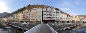
Kalovy Vary | Czech Republic | Stará Louka | Week 18

Karlovy Vary [english: Carlsbad; german: Karlsbad], assumed to be founded by Charles IV, Holy Roman Emperor and Czech King around 1350, lies about 120 km west of Prague and 150 km south of Leipzig at the confluence of the rivers Ohre and Teplá. 20th largest city in the Czech Republic.

Population: 50.000 [2014] | 56.000 [1991] | 55.000 [1930]

Emperor Charles IV, who appraised the healing power of the hot springs in the area, gave city privileges to the town, which was subsequently named after him. From 1526 Bohemia including Karlovy Vary belonged to the Habsburg Monarchy. In the 18th and 19th century Karlsbad gained more and more importance as the foremost spa town in central europe. Its visitors included Tsar Peter the Great, Goethe, Karl Marx, Morzart, Richard Wagner, Atatürk, Bach, Beethoven and Sigmund Freud amongst others. After World War II the german majority population was expelled from Karlsbad and the Czech Republic. Since 1989 the city is regaining its former spa town status, attracting international tourists, especially a large number of russian visitors.

The Stara Louka (german: Alte Wiese which means old meadow) lies at the centre of the Spa Area of the city along the Teplá river. It is regarded its most picturesque street and main esplanade. Here the valley is very narrow and the hills start right behind these buildings with a popular viewpoint pavillon seen above. A little further to the left the Art Nouveau Grandhotel Pupp is situated on this street, the major setting of the James Bond movie „Casino Royale“.

Find more material from Karlovy Vary in our Czech Republic overview.

Click for larger view:

Foto Karlsbad Alte Wiese Tschechien

For classic view and more infos about the street (german link):

Karlovy Vary Stara Louka

An alternative view of the Stara Louka as a classic panorama:

Karlovy Vary Stara Louka

Another street view (work in progress) from Carlsbad:

Kalrsbad Panorama Preview

Strasbourg | France | La Petit France | Week 14

Strasbourg [german: Straßburg; dutch: Straatsburg], founded by the Romans as Argentoratum in 12 BCE, lies 100 km west of Stuttgart, 200 km south of Frankfurt and about 450 km east of Paris, largest city of the french region Alsace and 7th largest city in France.

Population: 274.000 (2012) | 252.000 (1990) | 181.000 (1931) | 151.00 (1900)

Strasbourg is the capital of the Alsace (german: Elsass) region, however today it is also one of the capitals of europe, being the seat of the several european institutions like the Council of Europe and the European Parliament as well as the International Institute of Human Rights. Strasbourg’s historic city centre, the Grande Île, has been declared an UNESCO world heritage site in 1988. Historically the city often changed sides between german or french rulers. Since the late 17th century mainly french, german was still the main language till the end of WWII. Strasbourg is an important economic centre and its port is the second largest on the Rhine after Dusiburg, Germany.

La Petit France is a historic quarter in the centre of Strasbourg, part of its UNESCO world heritage site. Here the river Ill forms a number of channels with half timbered houses lining up on the shores and the narrow streets, most of them dating from the 16th and 17th century. La Petit France is now one of Strasbourg’s main tourist attractions.

Visit our archive for other streetline panoramas from France.

Click for larger view:

Panorama Strasbourg La Petit France

For classic view (german link):

Strasbourg Petit France

In our archive other streets and squares from Strasbourg are documented. Two unfinnished examples can be seen below.

Grand Rue

Strasbourg Grand Rue Panorama

Rue des Grandes Arcades

Architecture Strasbourg Rue des Grandes Arcades