Istanbul [old english: Constantinople; old german: Konstantinopel, Byzanz], founded as Byzantium by greek settlers around 660 BCE, lies on both sides of the Bosphorus partly on the european and partly on the asian continent, largest city in europe (though not completely situated on the european continent) and 5th largest city in the world.
Population: 14.377.000 (2014) | 6.620.000 (1990) | 741.000 (1935) | 943.000 (1900)
Istanbul is the most prominent and most populous city in Turkey, though the capital is Ankara. However it was the imperial capital for sixteen centuries for the East Roman Empire, the Byzantine, the Latin (being called Constantinople during all that time) and the Ottoman Empire. It is still the seat of the Orthodox Patriarchate. Istanbul is amongst the ten most visited tourist destinations in the world, with its attractive historical centre (an UNESCO world heritage site), its cosmopolitan Beyoglu side, the Bosphorous strait and its asian side.
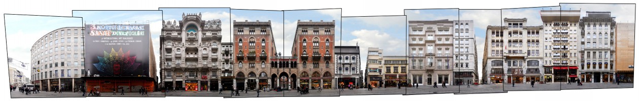
This is a section of the 1.4 km long Istiklal Avenue (turkish: Istiklal Caddesi) meaning Independence Avenue, also known by its former name Grande Rue de Péra. Until the 1920s it was the cosmopolitan artery of Péra, where lots of greek, italian, french and other foreigners, and especially merchants, lived for centuries. Péra (also called Galata) itself developed as a city next to Constantinople across the Golden Horn under Genoese (and partly Venetian) control from the 13th century. Most of the late Ottoman Style buildings in the street date to the 19th and early 20th century. The street experienced a long decline in the 20th century especially following anti-greek movements between the 50s and 70s. However since the 1990s the street regains its popularity, the old trams run through it again and buildings get restored, as can also be seen in this streetscape panorama.
We documented a number of streets and places in Istanbul, find a preview in our Istanbul overview.
Click for larger view:
![]()
For classic view and further details visit the archive:
![]()