Canterbury [old german: Kanterburg; welsh: Caergaint], first recorded (BC) as the main settlement of the celtic cantiaci tribe, became a Roman City as Durovernum Cantiacorum in the 1st century AD. Situated 80 km east of London and about 200 km west of Brussels on the shores of the river Stour.
Population: 55.000 [2011] | 43.000 [2001] | 24.000 [1931] | 25.000 [1901]
Canterbury was a capital for the celtic Cantiaci and for the Jute Kingdom of Kent, however its most prominent role has been in church history. Here the oldest church of the english speaking world can be found (St Martin’s Church), St Augustine started his apostle work and the christianisation of England here and the archbishop of Canterbury is the Primate of the Church of England. St Augustine’s Abbey, Canterbury Cathedral and St Martin’s Church form an UNESCO world heritage site. The city is also home to the world’s oldest School, the King’s School. Today the city has one of the strongest economies in the region and is one of the UK’s most visited tourist destinations.
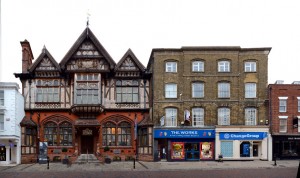
The panorama above shows one of the cities major non-religious landmarks, the Old Weavers House, at the right edge. It was used by the Huguenots and is one of the (still numerous) timber framed 16th and 17th century houses that survived the german Blitz bombings in world war II. St Peter’s street is named after St Peter’s church, which we see a little bit in the back on the left edge. The street connects the High Street at its east end with the Westgate in the west.
To find more published streetline views from the UK visit our United Kingdom archive.
Click for larger view:
For classic view and more infos about the streetview:
We have captured some more streetviews in Canterbury a few of which we present here in unfinnished previews:
Cathedral Gate | Buttermarket | Burgate
Great Stour | Westgate Grove
High Street | Royal Museum


